 |
|
|
|
|
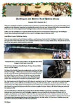
| Millington 1771 Enclosure & 1843 Tithes Apportionment |
|
The Millington parish enclosure award was dated 1771 and furthermore, in 1843, the tithes apportionment took place. John Nottingham has superimposed the various data over recent satellite imagery, the bold yellow line on the left-hand map being the border of the Millington civil parish as at 1771, with the dashed yellow lines denoting the 'close' (field) boundaries. Note that the western area including Great Givendale was included at the time but, in 1823, Great Givendale village (and nearby lands) was listed as a civil parish in its own right. Great Givendale is today again part of the Millington civil parish.
The names of the landowners of the closes allotted at enclosure, plus the field acreages, are listed in the table, noting that Lord Carlisle and St. John's College, Cambridge were in a small number of cases 'absentee landowners'. The field acreages vary widely between 200 and only 1-2 acres, with those in the Millington village area being even smaller. The right-hand map (with the 3 insets) shows the sub-plots within the village. In several areas, the landowners and acreages of the closes are not available in the enclosure data.
The 1842 tithes map covers only the limited area denoted by the brown transparency. Although this land was sub-divided into 30 separate sections (generally following the boundaries of the 1771 enclosure closes), in 1843 the sole landowners and sole occupier in the area were the Ecclesiatical Commissioners for England and Jonathan Hicks respectively.
To view the full-scale maps, please click on the 'View fullscreen' link, and Zoom into the maps and scroll around as required to read the data.
|
|
|
|