A Village and a Parish
In the East Riding of Yorkshire, springs of water issuing from the western escarpment of the Yorkshire Wolds form a beck that runs southwest onto the Vale of York and it is around this beck that the village of Bishop Wilton has grown up.
To the north of Bishop Wilton the main route from York to Bridlington climbs the Wolds to its highest point of 246 metres. It is just before this climb, at the bottom of Garrowby Hill, that a road runs south to Pocklington crossing the main street of the village and splitting it into two, a top or east end and a bottom or west end.
The wider Parish of Bishop Wilton stretches out to embrace the hamlets of Belthorpe, Youlthorpe and Gowthorpe.
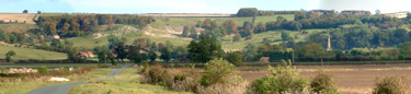
Bishop Wilton from the west looking towards the Wolds
The pages that follow explore the historical context of this stretch of land and of the people who have lived and worked on it.
Much of the material on this website is derived from the work of the late Mike Pratt of the now disbanded Bishop Wilton Local History Group which you can find out more about here.
With Local History Group meetings now finished and the last Bulletin in the series having been produced, this website is an archive of the Group's past activities from 2002-2012.
The bulletins can be purchased online here.
(c) Copyright 2009 Contributors. All rights reserved. |