|
Pocklington residents and visitors alike will be well aware of the extensive, ongoing residential housing developments within the town and especially around the outskirts. Even where non-residential buildings become inactive (e.g. the Health Centre on Barmby Road and the Cooperative store on George Street), they are soon replaced by terraces of 'town houses'. If anything, the pace of residential building seems to be accelerating, while comments such as 'What about infrastructure?' and 'When will it all end?' are common.
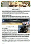
John Nottingham has produced a composite map to illustrate just how much our market town of Pocklington has expanded over the last century or so. As a base, the graphic shows the situation at the 1909 Ordnance Survey (including the 50 acres alongside West Green transferred from Barmby Moor parish in 1901), with the main features such as the Church, chapels, the railway station, the Union Workhouse, Pocklington School and other schools highlighted, along with relatively limited housing, but with none of the 'estates' as we now know them.
Yet by the 1971 Ordnance Survey, the area outlined in mauve shows that several estates had already come into being, including Algarth, The Oval and the original areas of Sherbuttgate, roughly doubling the built-up area. There was then a breather, with only Chapel Hill and the residue of Sherbuttgate being developed by the 1990s. However, the first 2 decades of the 21st century - and especially in recent years - have seen a very considerable expansion in the outlying parts of the town, as shown by the area outlined in pink, with several estates currently also under construction as at 1 May 2019 (blue) and further lands already approved for housing development (green).
A point of particular note is that, almost routinely, the outer limit of each new estate almost exactly follows the boundaries of a group of 'closes' (fields) as set out in the 1757 enclosure act. For example, the area approved for development on South Moor (green) encompasses a group of 11 enclosure closes.
So on the face of it, the built-up area of Pocklington town roughly doubled in the c. 60 years from 1909 to 1971 - but has again almost doubled in the succeeding c. 50 years. 'Where will it all end?' indeed.
To view the graphic at full-scale, please click on the 'View fullscreen' link. Then zoom in and scroll around to see it in more detail.
|