PocklingtonHistory.com
News
> Two Short Talks
> Old Shops part 2
> Pock pubs walk
> Woldgate Book Launch
> Low Catton walk
> 2023 AGM
> Book launch evening
> Pocklington Heritage Festival (2022)
> Sports Short(ish) Talks
Events
> Pocklington Local History Group
  21st Mar - 18th Century Pocklington

> Pocklington Local History Group
  18th Apr - The AGM and The ER
  Archives by Hannah Stamp

> Pocklington Local History Group
  18th Jul - A guided tour of Allerthorpe
  to include Allerthorpe church

> Pocklington Local History Group
  19th Sep - Pocklington's connection
  with the sea

Gallery
Market Place Market Place
Note the new building in the photo on the corner.
Regent Street Regent Street
Note the 'Old Red Lion Hotel'
Chapmangate Chapmangate
Note the independent chapel built in 1807 to the left.
Publications
Woldgate History Woldgate History

"A History of Woldgate School"

* 60 pages
* Fully illustrated
* Only £5.00
epp Exploring Pocklington's Past

* Peter Halkon
* Summary of
Pocklington Archaeology
* Only £5.00
Heritage Trail Heritage Trail

"A Pock History & Heritage Trail"

* 2nd edition
* 27 pages
* Old photos
* Only £4.99

People and Places Thumb Old Pock

"People and Places of Old Pocklington"

* 40 pages
* Old photos
* Only £5.99
Adieu WW1 Book

"Adieu to dear old Pock"

  * ww1 diary
  * 53 profiles
  * Local News
  * 299 soldiers
  * 246 pages
Newsletter

PDLHG Newsletters
#1 Oct 2020
#2 Dec 2020
#3 May 2021

William Watson
19th Century maps of Pocklington.

William Watson – Land Surveyor (1784-1857)

Two of the most important, and unique, maps of Pocklington were made by a remarkable man called William Watson a land surveyor of Seaton Ross, who eventually settled to live in Pocklington. His first map of Pocklington was made in 1844 which shows buildings shaded and stippled, roads yellow, water blue, grassed areas green.

1844 William Watson map

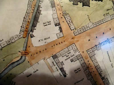
Part of William Watson’s 1844 Map

The 1855 Map had a considerable amount of further detail. Watson managed to combine the detail of what the houses actually looked like with the names and professions of the people who lived in each house. He did the same with a map of Market Weighton and I believe another one of Seaton Ross which I have not seen.

1855 William Watson map

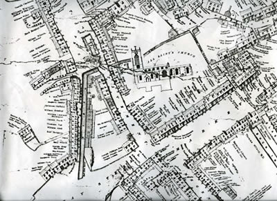
William Watson’s map of Pocklington of 1855

Both maps are available to purchase from Pocklington Town Council (see the links page).

Ref: Harris A. – “An East Yorkshire Land Surveyor: William Watson of Seaton Ross” Yorkshire Archaeological Journal Vol 45 1973 pp 149 - 157