|
William Watson of Seaton Ross
East Riding Farmer, Land Surveyor, Map and Sundial Maker 1784 – 1857
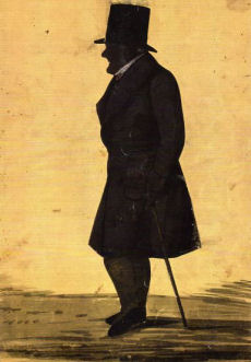 William Watson was born at Seaton Ross in the East Riding of Yorkshire on 17th May 1784, He was the fourth child of eleven to parents John and Sarah Watson. William’s family were farmers and following in that tradition of his parents and grandparents before him, he spent much of his early life in farming. For many years William lived and farmed at Seaton Lodge and in the early part of the 19th century set about cleaning the land of heath and furze, a task that was successfully completed in 1834. From his book of memorandums William describes his early years in farming:- William Watson was born at Seaton Ross in the East Riding of Yorkshire on 17th May 1784, He was the fourth child of eleven to parents John and Sarah Watson. William’s family were farmers and following in that tradition of his parents and grandparents before him, he spent much of his early life in farming. For many years William lived and farmed at Seaton Lodge and in the early part of the 19th century set about cleaning the land of heath and furze, a task that was successfully completed in 1834. From his book of memorandums William describes his early years in farming:-
“Began to burn sods about 14th May 1812 and between the 19th and 26th May 1812 he sowed “Oats Poland”. He goes on to say “Work began on the building of the new farmhouse following enclosing the common fields also in 1812.” His account of the 1812 harvest is as follows: “began harvest to mow oats (Poland) on the 26th September . Got all the corn in on the 24th October 1812. Had 173 quarters of oats in the first year about 4 quarters per acre”.
Right: Thought to be a self portrait silhouette drawn by Watson himself.
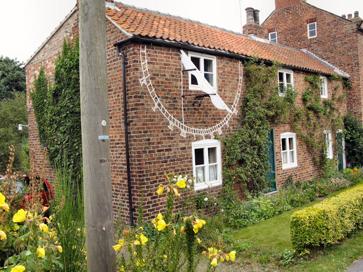 |
Dial Cottage - Seaton Ross |
Seaton Lodge was a tenanted farm like many others in Seaton Ross. The local landlord was Marmaduke Constable Maxwell of Everingham Hall & Park who leased the farm, sometimes known as Common Farm, of approximately 138 acres, to William Watson. From his book of memorandums William describes himself in verse,
“William Watson is my name
And with my pen I print the same;
I am a farmer, and they call
The house I live in Dial Hall;
Tis on the Common at Seaton Ross
About it grows ling and Moss;
I have liv’d all my life at Seaton
Which village is near Market Weighton;
On January twelfth I write
Eighteen Hundred and Twenty Eight”
During the period of his occupancy of the farm William began to develop his interests in surveying and the making of sundials. Records suggest that he was very likely responsible for several early local field plans of Seaton Ross and Everingham.
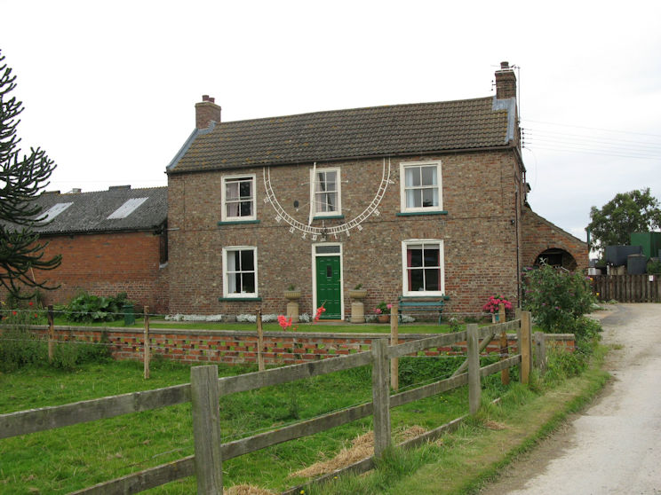 |
Dial Hall - Seaton Ross |
His interest in sundials began by making a sundial for the wall of his own farmhouse. This eventually extended to four – a sundial on each wall of the house! William subsequently renamed the farm “Dial House Farm”. His learning for sundial making is believed to have been self taught and he developed a talent for the making of sundials at Seaton Ross and the surrounding neighbourhood gaining considerable fame by this work. He also wrote poetry and in 1824 advertised the making of sundial in verse “If any person wants a Dial, Apply to me I’ll make a trial, I can make for any man, Upon a much improved plan, Five guineas is the price of one, and each mile distant Half a Crown; I make them to put on a wall, neat strong and true and that is all”.
Three fine examples of William’s sundials still exist in Seaton Ross namely; Dial Farm (1821), St. Edmunds Church (1825) and Dial Cottage (1850). The sundial on Dial Cottage is reputed to be one of the largest in the country being 12 feet in diameter painted on the wall of the cottage. In 1854 Forth’s of Pocklington (printers and stationers) printed William’s little book of directions entitled “Dialling Diagrams” being examples of fifty-four degrees of latitude; with an explanation for their construction.
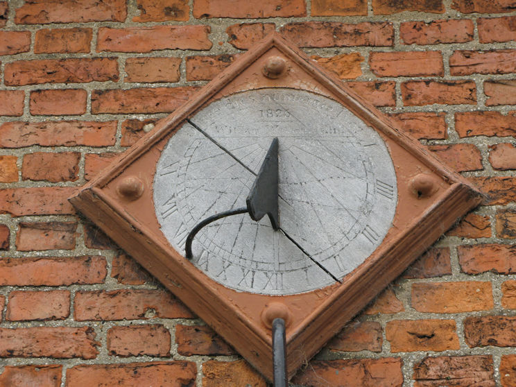 |
William Watson's sundial on St. Edmunds church, Seaton Ross dated 1825 |
William also had another interest and hobby – surveying and map making. He would measure roads and walk miles with his tape measure and paid an assistant to help him – to hold the other end of the tape. He drew every house in Seaton Ross in 1848 listing the occupiers, the landlord and the distance in miles, yards and feet from Pocklington and the distance of each house from the roadside. This skill lead to him being much in demand, with most of his commissions coming from local landowners who required accurate and precise maps drawn of their land. His local town plan of Seaton Ross June 1811 and his book of roads in Seaton Ross June 1828 are fine records of his early work in surveying and map making.
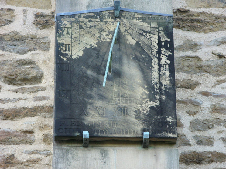 |
Pocklington Church Sundial believed to be made by Watson.
Quis solem dicere falsum audeat ? and under:—R. English and W. Cook. Churchwardens, 1820
The latin inscription translates to "Who dares to say that the sun is false?"
|
From William’s early maps and drawings his skills developed into his two major works – the detailed town maps of Market Weighton (1848) and Pocklington (1855). The maps show front elevations of buildings with notes of their occupiers and trade and use. The success of the Market Weighton Town Map led to its display at the Great Exhibition at the Crystal Palace in 1851.
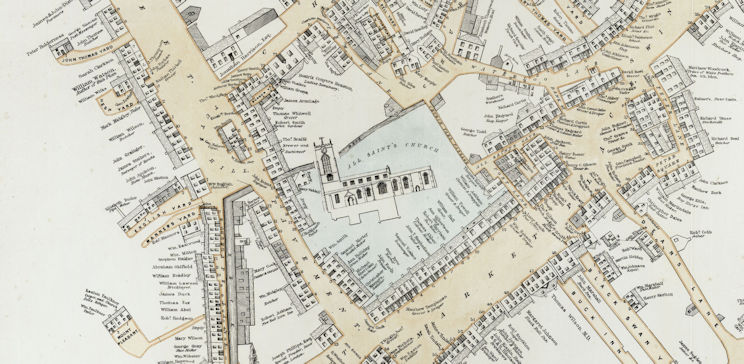 |
Watson's map of 1855 is a wonderful and unique example of cartography.
His house is marked on the plan (top left) |
There is a fine example of his town map of Market Weighton today in the lobby of the Londesborough Arms in Market Weighton, which is well worth a visit to fully appreciate the skill and talent of his own surveying, drawing and draughtsmanship. There is also a fine example of his town plan of Pocklington in the local Arts Centre in Pocklington.
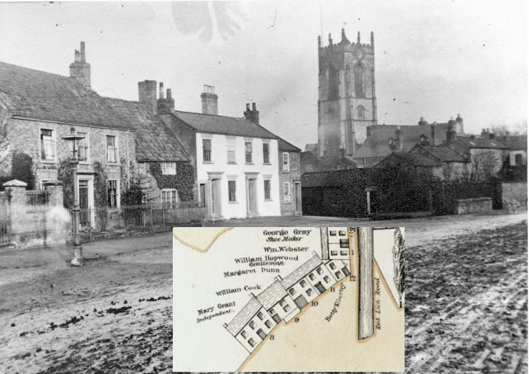 |
An old photograph of Railway St. Pocklington (1890's) showing the accuracy of Watson's surveying and map making. All the windows and doors are accurately drawn. |
William left farming and Dial Hall Farm Seaton Ross in 1838 with his brother George taking over the farm and for most of the rest of his life spent time land surveying, map making, making sundials, writing poetry, and writing daily accounts of general interest. He was an avid note keeper and diarist and made a comprehensive collection of epitaphs on gravestones in Seaton Ross and the surrounding area. He lived for a number of years in Pocklington and also spent time living in York, London and Market Weighton during the 1840’s. Music also formed an important part of his life – in November 1841 he advertised,
“William Watson would be glad to teach any children and young persons in music gratis at his house on Wednesday evenings and also on the same evenings to assist any full grown persons in singing the church tunes if he can get ten members of each class to be fixed a penny a night for being absent. The former class to commence at six o’clock the latter at seven and he would be glad to admit any persons and hearers if he can find room for them”.
 His work “A gamut for Singing Schools” was published in February 1849 price one penny when at this time William was living at Northgate Market Weighton. His work “A gamut for Singing Schools” was published in February 1849 price one penny when at this time William was living at Northgate Market Weighton.
He had numerous friends who helped him develop his book of penmanship being “autographs of William Watson and his friends”. This was a book of poems, drawings and stories from well-known people in the area, such as John Smith from Bielby who was a local inventor and also sundial maker. William and several of his circle of friends were members of the Mechanics Institute and Scientific Association. In February 1841 an article by William appeared in their Mechanics Magazine on how to construct a simple instrument for finding the meridian line.
William spent the latter part of his life collecting day-to-day information and writing in his journal everyday events. The book of memorandums records details of the weather on particular days, the observations of the night sky and miscellaneous information of day-to-day life in the village. His hobbies also extended into amateur astronomy and it is believed he had an observatory in Seaton Ross for his stargazing from which he drew star charts and constellations of the heavens.
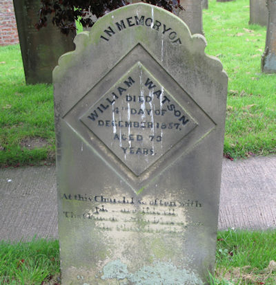
William was also a bachelor all his life. He died on Monday 4th December 1857 and is buried in St. Edmunds churchyard at Seaton Ross. On his gravestone is the following quaint and appropriate epitaph,
“At this church I so often with pleasure did call,
That I made a sundial upon the church wall”.
Although William died nearly 150 years ago, his memory should live on for years to come. His skills as a sundial maker had a timeless quality relying on solar power for their inspiration. His maps, plans and memorandums provide us with a vivid and unique record of life in Georgian and Victorian East Yorkshire.
He was a true ‘sun’ of Seaton Ross.
Malcolm Young – Seaton Ross – 2005
|

