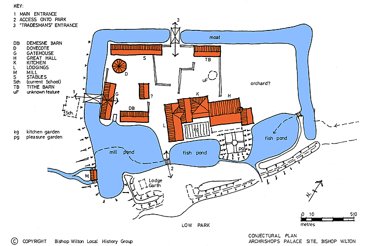
The Layout of the Archbishop' Palace Site
By Andrew Boyce [Published in Local History Bulletin 14, October 18th, 2006]
previous item | up | next item

This article continues and extends the work written up in Bulletin 13 [Local History Bulletin 13, February 8th, 2006] under the same heading.
The conjectural plan above is based on the current Ordnance Survey 1:1250 digital plan which shows the remains of the moat, fishponds, banks and the circular feature in the north-west corner of the site.
In addition, by interpolation of features seen on aerial photographs taken by A J Crawshaw (Aeroscene Ltd, York), a conjectural layout of buildings, walls and other features has been superimposed. From published sources (see Bibliography below) an interpretation of possible uses for the buildings has been proposed.
By kind permission of the landowners (The Garrowby Estate) and the lessees and tenants of the land, a site walk was undertaken in May 2006 during which it was possible to appreciate the extent and scale of the monument and to further interpret the “lumps and bumps” seen on the photographs.
The plan has benefited from a number of discussions with other members of the BWLHG [Bishop Wilton Local History Group] but the final result is the author’s own work. Any errors, omissions, shortcomings or wild exaggerations are entirely his responsibility.
The plan is a first attempt to bring this intriguing site to life; any comments, criticisms, ideas or greater wisdom, would be gratefully received.
Bibliography:
- The Buildings of England, Yorkshire: York and the East Riding; Nikolaus Pevsner & David Neave, Penguin Books, 1995 (ISBN 0 4 07061 2)
- Dovecotes, Peter & Jean Hansell, Shire Books, 2001 (ISBN 0 7478 0504 0)
- Water & Wind Power, Martin Watts, Shire Publications, 2005 (ISBN 0 7478 0418 4)
- Churches in the Landscape, Richard Morris, J M Dent & Sons Ltd, 1989 (ISBN 0 460 04509 1)
- The Moated Sites of Yorkshire, H E Jean Le Patourel, Society for Medieval Archaeology Monograph Series no: 5, London 1973
- The Archaeology of Mills & Milling, Martin Watts, Tempus Publishing Ltd., 2002 (ISBN 0 7524 1966 8)
- Monasteries in the Landscape, Mick Aston, Tempus Publishing Ltd., 2000 (ISBN 0 7524 1491 7)
- The English Medieval House, Margaret Wood, Bracken Books, 1985 (ISBN 0 946495 02 5)
- East Riding Water Mills, K J Allison, East Yorkshire Local History Society, 1970
- CBA Research Report No: 17, Medieval Moated Sites, Ed. F A Aberg, 1978
- English Heritage Scheduled Monument No: SM21054 description of 1992.
- English Heritage Monument Class Descriptions: - Magnates Residences (medieval), April 1990
- Water Mills (medieval), November 1989
- Fishponds, September 1988
- Moats, February 1988
(c) Copyright 2009 Contributors. All rights reserved. |